Guide to Orienteering
Orienteering is an exciting and challenging outdoor sport that exercises both mind and body. The aim is to navigate between control points marked on an orienteering map.
In orienteering, the challenge is to complete the course in the quickest time by choosing your own best route. As a recreational activity, it does not matter how young, old, or fit you are — you can run, jog, or walk at your own pace.
Map
The orienteering map is a very detailed representation of the terrain. It also shows where you are allowed to run and where you are not. In urban sprint events, the usual scale is 1:4000, meaning that 1 cm on the map represents 40 m in the terrain. Orienteering map symbols .
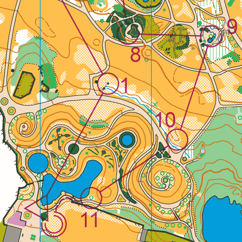
Course
The course is shown on your map with the following symbols:
Triangle = start, numbered circles = control points, double circle = finish.
You must visit the controls in the order in which they are numbered. At the start, you “punch” the control by placing your Sportident card into the unit, which starts the timer. At the finish, you download the information stored on your Sportident card. This shows whether you have completed the course in the correct order.
You choose your own route between the control points. The challenge is to choose the fastest routes and execute them well. See a map with an orienteering course .
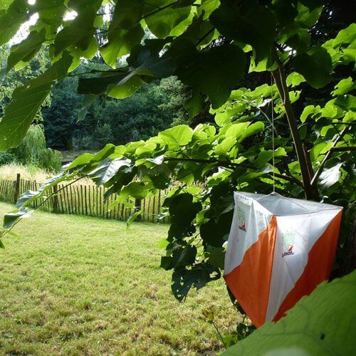
Control Points
Control points are marked with an orienteering flag and an electronic timekeeping unit. Each control has a unique code, for example 31. On the map, you will also find a control description with the codes for all controls on your course. By checking the code against the control description, you can make sure that you are at the correct control.
If you accidentally punch a wrong control in between, it does not matter: simply continue to your next correct control. However, you must visit the required controls in the correct order: Start–1–2–3–…–Finish.
Start Procedure
In contrast to many running races, orienteering uses individual start times. Each minute, one runner — or one team in the Team Challenge — starts on each course. A start list will be published in advance.
Please arrive at the start 3 minutes before your start time to clear and check your Sportident card.
What do I need to bring?
- Sport clothing and running shoes.
- You can collect your timing chip at the event centre.
- The map will be handed to you at the moment of your start.
- For your first sprint orienteering experience, you do not need a compass. Just orientate the map using the main features around you. Once you gain more experience, a compass can help speed up your navigation.
Which class should I choose?
Controls are usually easy to find in urban areas. The main difference between classes is the length of the course and the complexity of the route choices between controls.
If this is your first experience with orienteering, we recommend either the Newcomers class or the Team Challenge for maximum fun.
In the Team Challenge, you can team up with friends and run together. Each team member receives a map, but the team completes the course together using one Sportident card.
The Newcomers class is for individual starters. Course lengths for both options will be approximately 3–4 km per stage, depending on your own route choices.
VOC is an open event, so all classes are available to you. You are not restricted to these recommendations.
Partners
Partners & supporters
Special thanks to our partners and supporters for helping make the Vienna O Challenge a better event.